~22 miles @ ~ 22 min/mi
Bats flit through the beam of my flashlight as Caroline Williams and I climb the steep purple-blazed Roaring Run Trail. It's midnight, the start of Easter morning, and thousands of brilliant stars are beaming down upon us. During the past five hours we've done about 15 miles on the Massanutten Mountain Trails course, including a couple of bonus miles when we missed the turn off the dirt road.
As we backtrack in search of a trail marker I recount ultrarunner Eric Clifton's thoughts about getting lost during a major race. Yes, my right knee and left metatarsals ache. Sure, my bronchitis occasionally gives me a coughing fit. Admittedly, I've lost a few pounds from dehydration and I'm about to run out of water.
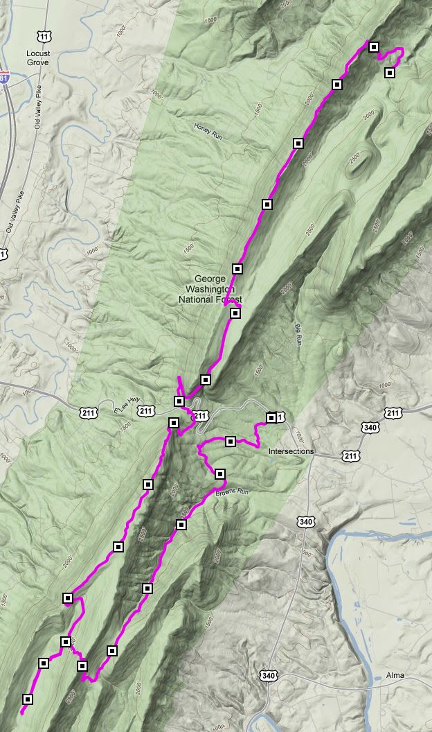
But it's all good. Caroline is wonderful to run with, and Walker Williams is infinitely patient as our crew. We're doing the 2010 "Chocolate Bunny", a VHTRC fun run on Massanutten Mountain. The little vermiform appendix hanging down at the bottom of the GPS map shows where we went astray.
(markers on our path indicate one mile intervals; thanks to GPS Visualizer and Google for maps)
Walker drives Caroline and me out to Massanutten Mountain on Saturday afternoon. We arrive at the Chocolate Bunny start/finish area, Gap Creek, and decide to start our trek early. At 6:20pm Walker hugs Caroline, I give him a manly wave, and we're off!
Caroline has been here many times, but my only previous experience was the 2008-01-20 - Massanutten Mountain South Training Run with friend Caren Jew, when we encountered ice, snow, and temps in the teens. Today conditions are near-perfect — thermometer dropping from the 70s into the 50s — but the steep climbs and rocky terrain demonstrate that it's nontrivial to maintain even a 20 min/mi pace on the Massanutten Trail.
For the first mile we follow the Jawbone Gap Trail up ~800 feet and join the orange-blazed Massanutten Trail. It follows the ridgeline of Kerns Mountain. Southward we go for ~5 miles. A beautiful fuchsia sunset distracts us occasionally from the rocks underfoot. At 8pm it's dark enough for us to turn on our flashlights. Caroline falls once but catches herself on her hands without major damage. Her headlamp is too faint to illuminate much, but fortunately I have an extra light to lend her.
Fast runners who started at 7pm now begin to pass us. We step aside and cheer as they speed by. Bobby Gill pauses to take a photo of Caroline and me. At mile ~6 we descend to Crisman Hollow Rd, where we jog downhill at ~12 min/mi for a couple of miles to the first aid station, the Park Service visitor's center at New Market Gap on US-211.
Here ever-helpful Walker meets us, we refuel, and I Tweet our status. We check in with the race officials, grab snacks, and begin the giddy thousand-foot climb to Bird Knob. Contrary to the official turn sheet for the race [1], once we're near the top we follow a white-blazed connector trail. Caroline reassures me that it's the right path, but after we get on it we see no other runners.
The trail eventually takes us to a forest road. We trot downhill and chat while scanning the shoulder for a trail sign. After more than a mile Caroline is pretty sure that we've missed it, so we turn around and trudge back. Now of course the post is blatantly obvious. Up we climb, first on the purple-blazed Roaring Run Trail, then on the pink Browns Run Trail. Boggy patches and ankle-deep water crossings are frequent, even though it hasn't rained for a week.
As we proceed I become increasingly fatigued. Besides residual bronchitis and ITB problems, and my normal left metatarsal issues, I perhaps should be taking in more electrolytes. I'm also feeling a bit dizzy now, maybe from peering at the circle of my flashlight beam on the rocks and sticks underfoot.
Whatever the reason, I warn Caroline that I'm thinking of stopping when we see Walker next, which I estimate will be about mile 22. We've been alternating the lead, but now as the path gets trickier Caroline takes over. I give her my bright handheld LED flashlight and stagger along behind in the fading illumination of my extra headlamp. The best indication of the right path now is by sound: when I'm on course the crunching of the brush underfoot is less loud. We both begin to stumble more often.
Finally at 2:20am we hear traffic, see lights, and there's Walker, awaiting us at the second US-211 parking lot — hooray! Caroline feels good and decides to do the final five miles solo, even though Walker and I try to persuade her otherwise. I rehydrate as Walker drives the minivan back up Crisman Hollow Road to the start/finish area. We tell Race Director Tom Corris the situation and he sighs but admits that Caroline's insistance on running alone is not unexpected. She's that kind of trail gal!
Tom gives us all chocolate bunnies for participating and we move the car down the road to where Caroline's trail emerges. I nap while Walker goes into the woods along the Scothorn Gap Trail to make sure Caroline doesn't miss the final turns. At about 4:20am they're at the car and the adventure is over.
I'm still on the MMT 100 waiting list, but after tonight's run I've got serious doubts about my abilities to do the race this year. Massanutten is tough, and 100 miles is a long way!
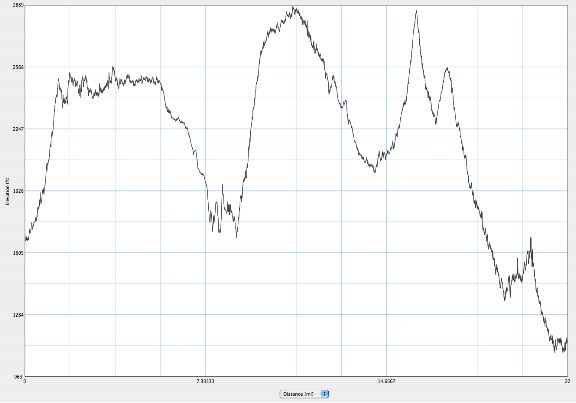
The official chart at [2] says the Chocolate Bunny offers 5,400 feet of climb. I missed a thousand or so of that by skipping the last 5 miles that Caroline did solo, but we both got several hundred bonus when we went off course. This graph is my GPS's altitude chart, with horizontal axis showing distance in miles (0-22) and vertical depicting elevation in feet (~1000 to ~2900).
^z - 2010-04-05